St. Clair Municipal
Ramp - Boating Access Site
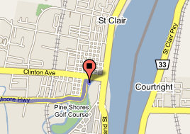
Take exit 257 to St Clair - go 0.6 mi
Turn right at Fred W Moore Hwy - go 7.0 mi
Turn right at Pine St - go 245 ft
Turn right at S 5th St - go 128 ft
Civil Division: St Clair
County: Saint Clair
Coordinates: Lat:42.819960, Lon:-82.489025
Town, Range, Section: , ,
Waterbody: Saint Clair River
Surface Area (Acres):
Site Rules:
(1) Special rules apply, such as special closing hours, rules against
consumption of
alcoholic beverages, or others. This designation is
also used where the
site rules are established by an agency other than
the Department of
Natural Resources.
Ramp Description:
A hard-surface ramp with sufficient water depth and lake or impoundment
size to accommodate
all trailerable watercraft (minimum of 2.5 - 3 feet deep
at a distance of 20
feet from shore). The site is signed.
Site Administrator:
St. Clair City
Contact Number: (810) 329-5299
Total Parking Spaces: 80
Water Craft Controls:
This site has a watercraft control